





El Chalten, Argentina: Best Hikes & Travel Tips
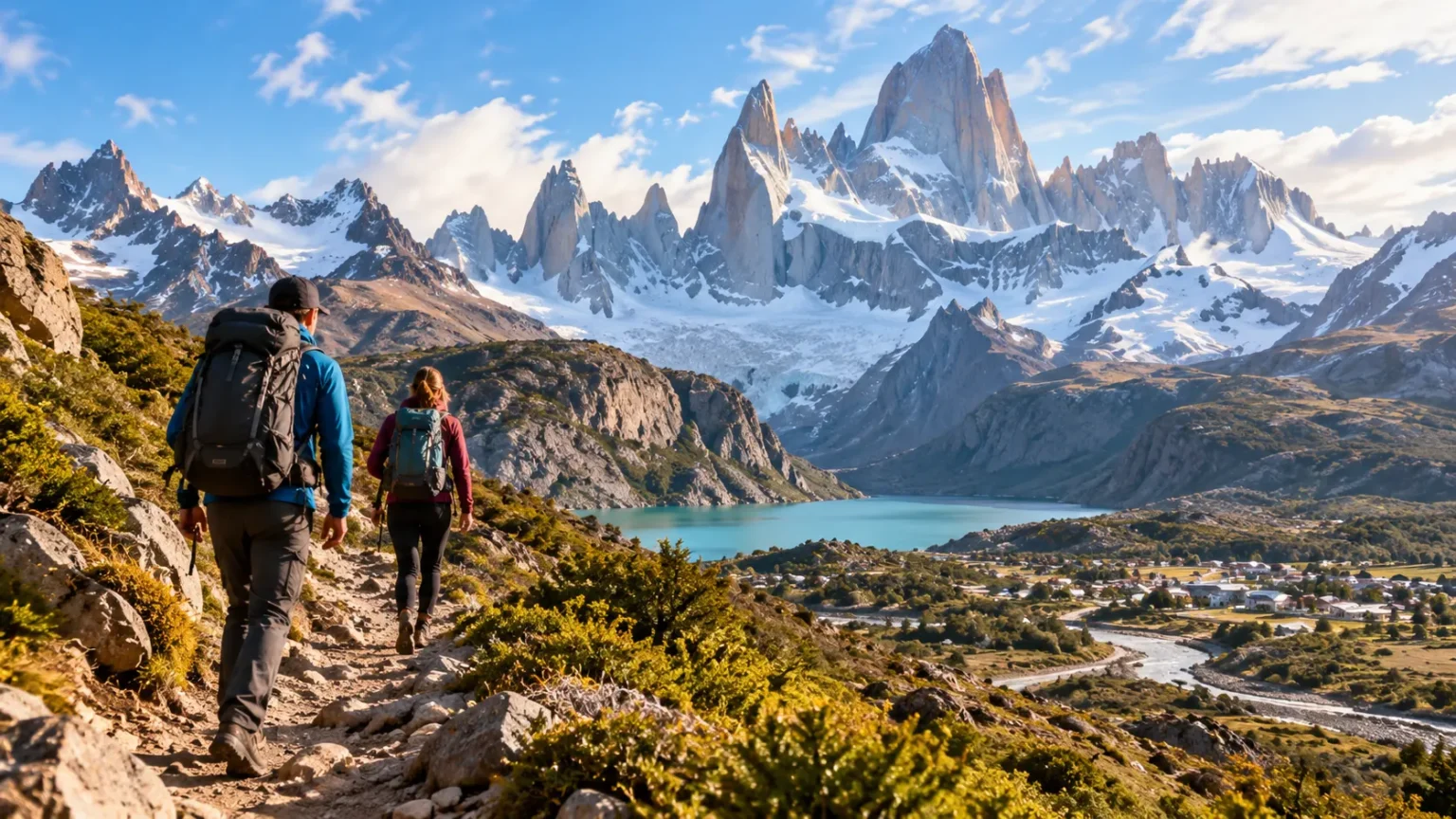
El Chalten, Argentina, is a small mountain town surrounded by some of the most dramatic landscapes in Patagonia. Set beside the northern section of Los Glaciares National Park, it provides direct access to granite peaks, glacial lakes, native forests, broad valleys, and some of Argentina’s best hiking trails. Mount Fitz Roy, also known locally as Cerro Chaltén, dominates many of the classic views, while the needle-like Cerro Torre creates an equally unforgettable skyline. What makes the destination particularly appealing is how many trails begin within walking distance of town. Travelers can leave their accommodation in the morning and start hiking without arranging complicated transfers. This combination has made El Chalten one of South America’s most celebrated trekking destinations.
The best hikes in El Chalten range from easy viewpoints suitable for a relaxed afternoon to demanding full-day treks requiring several hours of sustained walking. Laguna de los Tres is the signature challenge, rewarding hikers with an extraordinary close-up view of Fitz Roy above a turquoise glacial lagoon. Laguna Torre follows a gentler valley toward Cerro Torre and its surrounding glaciers, while Loma del Pliegue Tumbado climbs above the valleys for sweeping panoramas of the entire mountain range. Shorter options such as Laguna Capri, Mirador de los Cóndores, and Chorrillo del Salto make it easy to fill rest days without committing to another long trek. This variety means visitors do not need to be expert mountaineers to enjoy Patagonia’s scenery.
Weather plays a major role in every El Chalten itinerary because Patagonia can change character remarkably quickly. A calm blue morning can become windy, cloudy, rainy, or dramatically colder within hours, even during summer. For this reason, travelers usually benefit from staying several nights rather than arriving for one tightly scheduled hiking day. Extra time lets you place Laguna de los Tres or another priority trek on the clearest forecast window instead of hiking simply because your itinerary says you must. This guide covers the best El Chalten hikes, trail difficulty, when to visit, transportation from El Calafate, accommodation, packing, safety, park access, and itinerary planning. With flexible expectations and suitable gear, El Chalten can be one of the highlights of an Argentina trip.
Why El Chalten Is One of Patagonia’s Best Hiking Destinations
El Chalten sits in Santa Cruz Province in southern Argentina, close to the Chilean border and within the spectacular Andean landscape of Patagonia. The town is small enough to walk around easily, yet it provides restaurants, bakeries, supermarkets, outdoor shops, accommodation, equipment rental, and other services useful to hikers. Unlike destinations where major trails require hours of driving from a resort town, several famous El Chalten hiking trails begin almost directly from residential streets. This creates an unusually convenient trekking environment where the mountains feel closely connected to everyday town life. You can eat breakfast, walk to a trailhead, spend the day beneath glaciers and granite towers, and return to a warm meal without needing your own vehicle.
The star of the landscape is the Fitz Roy massif, whose dramatic granite summits rise steeply above forests and glacial valleys. Cerro Torre provides another visual centerpiece with its sharp, slender profile and surrounding ice fields. These formations give El Chalten a scale that photographs rarely communicate properly, particularly when the clouds lift and the complete mountain skyline becomes visible. Trails approach the peaks from several directions, so visitors see different combinations of forests, lakes, rivers, glaciers, and mountain walls depending on the route they choose. Even shorter hikes can deliver memorable views without requiring a full expedition. This accessibility makes El Chalten attractive to casual walkers, experienced trekkers, photographers, climbers, and travelers simply hoping to spend time outdoors.
Most classic day hikes are self-guided and follow recognizable trails, although conditions can become considerably more demanding with snow, ice, strong winds, or poor visibility. Hiring a qualified guide can still be worthwhile for travelers who lack mountain experience, prefer local interpretation, or plan more technical adventures. Guides can also be useful during shoulder seasons when snow or changing trail conditions complicate navigation. The town has a long relationship with mountaineering, so outdoor culture is part of its identity rather than an activity added mainly for tourists. Equipment rental makes it possible to obtain certain items locally if you arrive without everything required. However, essential clothing and comfortable footwear should ideally be tested before your trip.
Another advantage of El Chalten is that hiking experiences can be matched to available time and energy. Someone with only a few hours can visit Mirador de los Cóndores or Chorrillo del Salto, while a traveler with half a day might choose Laguna Capri or Mirador del Torre. Full-day hikers can attempt Laguna de los Tres, Laguna Torre, or Loma del Pliegue Tumbado. Multiple-day itineraries provide opportunities to combine the major routes while keeping one flexible day for poor weather. This layered trail network also helps mixed-ability groups, because not everyone needs to complete the hardest hike to experience Fitz Roy or Cerro Torre views. Good trip planning is therefore less about completing every trail and more about choosing walks appropriate to your interests and condition.
El Chalten also rewards travelers who appreciate slow days between demanding hikes. Cafés, bakeries, local restaurants, and mountain views give the town an atmosphere that encourages recovery rather than constant sightseeing. Watching the weather move across Fitz Roy can become an activity in itself, especially when low clouds suddenly open around sunset. Nearby roads and excursions can lead toward Lago del Desierto, additional waterfalls, kayaking, horseback riding, and other outdoor experiences when legs need a break from long trails. Autumn brings striking forest colors, while long summer evenings make outdoor days feel exceptionally spacious. El Chalten works best when treated as a mountain base rather than a checklist destination, allowing conditions and energy levels to shape each day.
Laguna de los Tres: The Classic Fitz Roy Hike
The Laguna de los Tres hike is the trail most closely associated with El Chalten and should be high on the list for travelers with suitable fitness and weather. The classic round trip from town covers roughly 25 kilometers and commonly requires around eight to nine hours, although individual pace and stops can change the total substantially. The route eventually reaches a spectacular glacial basin directly beneath the granite walls of Fitz Roy and neighboring peaks. Much of the hike is manageable for regular walkers, but the final climb is considerably steeper and more strenuous than the earlier sections. Because this section can become slippery or difficult in bad weather, conditions should be considered as carefully as overall fitness.
Starting from the northern end of El Chalten, the trail climbs away from town before opening onto impressive views of the Río de las Vueltas valley. It then continues through changing Patagonian landscapes where forest, open ground, streams, and mountain viewpoints break up the distance. Laguna Capri is located along one of the route options and provides an attractive objective for people who decide not to complete the full hike. As Fitz Roy appears through gaps in the trees, the mountain gradually seems to grow larger rather than simply remaining a distant landmark. The trail eventually approaches the area below the final ascent, where hikers should assess their remaining energy, weather, daylight, and trail conditions before continuing.
The final climb toward Laguna de los Tres is what gives the trek its demanding reputation. The trail rises sharply over rocky terrain, and the elevation gained over a relatively short distance makes progress significantly slower than on the preceding valley sections. Taking steady steps is usually more efficient than trying to climb quickly and needing frequent long rests. Trekking poles can be useful for balance and may be especially appreciated during the descent, although they are not mandatory for everyone. Strong wind, loose surfaces, snow, or ice can increase difficulty dramatically. Reaching the lagoon is satisfying, but turning around when conditions become unsafe is always a better decision than treating the viewpoint as something that must be reached regardless of circumstances.
At the top, Laguna de los Tres sits below Fitz Roy in a stark mountain amphitheater that creates one of Patagonia’s most recognizable views. The water can appear turquoise or deep blue depending on light and weather, while snowfields and glaciers surround parts of the basin. When conditions are clear, the granite towers feel remarkably close compared with viewpoints lower in the valley. Hikers can also explore an additional nearby viewpoint toward Laguna Sucia when conditions and energy allow, though care is needed on rough terrain. Photography is especially dramatic around early light, which is why some experienced hikers begin very early. Most visitors, however, should prioritize safe daylight hiking and favorable weather over attempting a particular photograph.
Carry enough food, water, sun protection, warm layers, waterproof protection, and an independent light source for this trek. Patagonia’s strong sun and wind can exist simultaneously, making it possible to feel cold while still receiving substantial ultraviolet exposure. Check current trail conditions before leaving because snow can remain on the upper route outside the warmest months. Starting early creates additional time for breaks and reduces the chance of descending in darkness after an unexpectedly slow day. If the full distance seems too ambitious, hiking only to Laguna Capri or one of the Fitz Roy viewpoints still provides a rewarding experience. The best version of Laguna de los Tres is the one you can complete safely rather than the one that pushes far beyond your preparation.
Laguna Torre, Loma del Pliegue Tumbado, and Other Best Hikes
Laguna Torre is the second major full-day hike most visitors consider after Laguna de los Tres. The route is approximately 19 kilometers round trip and usually takes about seven to eight hours depending on pace, although its terrain is generally less punishing than the final approach to Laguna de los Tres. The trail follows the Fitz Roy River valley toward Cerro Torre, eventually reaching a glacial lake where floating ice can sometimes be visible. Cerro Torre’s slender granite summit and the surrounding Adela range create a dramatically different mountain scene from Fitz Roy. The relatively moderate gradient makes this hike an excellent choice for travelers wanting a long day without the same steep final ascent found on the Fitz Roy route.
Travelers without enough time or energy for Laguna Torre can walk only as far as Mirador del Torre. This shorter option reaches an elevated viewpoint where Cerro Torre and the surrounding peaks can be visible on clear days. Because the walk requires only part of the full trail, it works well during arrival day, a shorter weather window, or a recovery day between longer treks. Morning light can be especially attractive in the valley, although cloud cover ultimately matters more than the exact hour. The trail begins close to town, maintaining the convenience that defines hiking in El Chalten. If weather completely hides Cerro Torre, the forest and river scenery still make the walk pleasant without committing to the full distance.
Loma del Pliegue Tumbado offers one of the best alternatives for hikers who want a broad panorama rather than finishing beneath one particular mountain. The trail begins near the national park visitor area and climbs steadily above the surrounding valleys over a full-day outing. From higher sections, hikers can look toward Fitz Roy, Cerro Torre, Lago Viedma, and large areas of the national park in a single sweeping view. The upper terrain is highly exposed, making wind one of the major considerations on this route. Even in summer, temperatures can feel surprisingly cold when clouds and strong winds arrive. For photographers and hikers interested in understanding the geography of the region, the panoramic perspective can be exceptional.
Laguna Capri is one of the best shorter hikes for travelers who want classic Fitz Roy scenery without dedicating an entire day to trekking. The route shares part of the broader Fitz Roy trail system and usually fits comfortably into a half-day outing for many visitors. The lagoon provides a peaceful foreground for views toward the mountain range when skies cooperate, while surrounding forest creates attractive picnic areas and sheltered sections. Because the route is easier than Laguna de los Tres, it can work well as a first hike after arriving in town. It is also a useful backup option when the weather window is too short for a major trek. A shorter hike with clear mountain views can easily be more rewarding than a longer route completed entirely in cloud.
For very easy walking, Chorrillo del Salto and the Mirador de los Cóndores area provide worthwhile options close to El Chalten. Chorrillo del Salto leads through forest toward an attractive waterfall and can be particularly useful on a relaxed day or when mountain visibility is poor. Mirador de los Cóndores climbs from near the park visitor center to an elevated viewpoint over town and the surrounding landscape. Nearby viewpoints can reveal the scale of the valley without requiring a full day’s effort. These shorter trails are also useful when waiting for a bus later in the day, although luggage should remain securely stored rather than carried unnecessarily. Combining one or two short walks with longer hikes creates a more balanced El Chalten itinerary than attempting difficult trekking every day.
Best Time to Visit El Chalten and What the Weather Is Really Like
The main trekking season in El Chalten runs through the warmer months of Patagonia, broadly from spring into early autumn. October through April is particularly popular because daylight is longer, tourism services operate more fully, and major trails are usually more accessible than during winter. December, January, and February bring the longest days and generally the greatest number of visitors. Summer does not guarantee calm or warm conditions, however, because Patagonia remains famous for powerful winds and rapid weather changes. Temperatures can feel pleasant while walking in the sun and significantly colder within minutes after cloud and wind arrive. Packing for multiple conditions remains necessary regardless of the month printed on your ticket.
November and March can be excellent choices for travelers seeking a balance between hiking conditions and somewhat lower visitor numbers. Trails may feel less busy than during the busiest weeks of midsummer, while days are still generally long enough for major walks. Early or late snow remains possible, especially at higher elevations, so conditions should be checked locally rather than assumed from season alone. Accommodation choices can also be easier outside peak holiday periods, though popular properties still fill during favorable trekking months. Photographers may appreciate lower sun angles and changing vegetation during the shoulder seasons. Travelers who value flexibility often find these months particularly attractive because the destination retains much of its summer accessibility without always feeling as busy.
Autumn transforms forests around El Chalten with combinations of yellow, orange, red, and brown foliage. March and April can therefore be especially beautiful for landscape photography, although days become shorter and temperatures decline as the season advances. Higher sections of trails may begin receiving more frequent snow or ice, and some tourism services reduce operations as winter approaches. A flexible itinerary becomes even more important because a few poor-weather days can remove a large portion of a short trip. Warm gloves, a hat, waterproof layers, and reliable footwear should be treated as standard trekking equipment rather than emergency extras. Autumn visitors who accept variable conditions can experience some of the region’s most atmospheric scenery.
Winter changes El Chalten substantially. Snow, ice, freezing conditions, reduced daylight, and limited services make many hiking experiences significantly more complicated than during summer. Some trails may still be accessible to people with appropriate experience and equipment, but classic summer descriptions should not be used to judge winter difficulty. Trail markings can become obscured, and conditions on exposed terrain can deteriorate quickly. Travelers planning a winter visit should seek current local advice and consider qualified guides where necessary. The quieter atmosphere can be appealing, but winter El Chalten should be approached as a different type of mountain trip rather than simply a less crowded version of January.
Regardless of season, weather forecasts should guide the order of your hikes rather than determine whether the trip is worth taking at all. Mountain forecasts remain imperfect, and Fitz Roy can disappear behind clouds even when conditions in town feel reasonable. Check forecasts each evening and again before departing, then place your highest-priority hike on the strongest-looking visibility window. Keep shorter walks or town time available for uncertain days. Wind forecasts deserve particular attention for exposed routes such as Loma del Pliegue Tumbado, while snow and ice matter greatly for the upper Laguna de los Tres approach. El Chalten rewards travelers who cooperate with the weather rather than trying to force the landscape into a rigid schedule.
How to Get to El Chalten and Where to Stay
Most international and domestic travelers reach El Chalten through El Calafate, the larger Patagonian tourism center located roughly 220 kilometers to the south. El Calafate has the region’s main commercial airport and provides connections with major Argentine cities, making it the natural gateway for many itineraries. Regular bus and transfer services operate between El Calafate and El Chalten during the main travel season, with the road journey typically taking around three hours depending on service and conditions. The route is paved and crosses broad Patagonian steppe before the mountains gradually dominate the horizon. Renting a car is another option, although a vehicle is not necessary for the majority of classic El Chalten hikes.
Travelers combining El Chalten with Perito Moreno Glacier often spend time in both El Calafate and El Chalten rather than attempting long day trips between them repeatedly. El Calafate works as the base for glacier excursions, while El Chalten is much better for hiking because trailheads are close to town. A common itinerary is to arrive in El Calafate, visit the glacier, travel north to El Chalten for several nights, and then return before the departing flight. Leaving a generous transportation buffer is sensible because Patagonia’s weather can occasionally complicate travel plans. Booking a long-distance bus that arrives only shortly before a flight creates avoidable stress. An overnight in El Calafate before an important morning departure can provide useful insurance.
Accommodation in El Chalten ranges from hostels and simple guesthouses to apartments, comfortable hotels, and mountain-oriented lodges. Location is usually less critical than in a large city because the central area is compact and walkable. Staying toward the northern end of town can slightly shorten access to the Laguna de los Tres trailhead, while central accommodations place restaurants and shops close by. Properties farther from the center may provide quieter surroundings or broader views. Travelers planning to cook should check whether their accommodation includes kitchen facilities, especially because restaurant costs can add up over several nights. During high season, booking early provides more choice because the town has limited capacity relative to its popularity.
Hostels remain popular with hikers because they provide affordable beds, communal kitchens, social spaces, and opportunities to meet other travelers considering the same trails. Private rooms in guesthouses or small hotels may be more appealing after long trekking days when quiet recovery matters. Apartments can work particularly well for couples, families, or longer stays because the ability to prepare breakfast and packed lunches saves both time and money. Luxury is not essential for enjoying El Chalten, but good heating, a comfortable bed, and a reliable place to dry wet clothing become surprisingly valuable after a windy or rainy hike. Choosing accommodation around recovery needs can improve the entire trekking experience more than paying primarily for decorative extras.
Book enough nights to create flexibility rather than calculating the minimum time required to walk two trails. Three nights can provide a quick introduction, but four or five nights offer a much better chance of placing major hikes around changing weather. Serious photographers or travelers hoping to complete several full-day routes may prefer even longer. Remember that arrival and departure days are not always usable for major hiking, especially if transport schedules leave only a few hours of daylight. Short trails fit those partial days well and prevent them from feeling wasted. The ideal length is ultimately determined by how many major hikes you want to attempt and how much weather flexibility you are willing to build into the trip.
Essential El Chalten Hiking Tips, Park Access, and What to Pack
Layering is the foundation of sensible Patagonia hiking clothing. Begin with a comfortable moisture-managing base layer, add insulation appropriate to the forecast, and carry an outer shell that protects against wind and rain. A warm hat and gloves deserve space in the backpack even when town feels mild during breakfast because exposed viewpoints can be much colder. Avoid relying on one bulky jacket that cannot adapt when your body heats during a climb. Comfortable hiking shoes or boots with reliable traction are equally important, particularly for rocky or wet terrain. Whatever footwear you choose should ideally be broken in before arrival rather than tested for the first time on a 25-kilometer hike.
Carry food and water appropriate to the length of the trail because full-day routes do not provide cafés or shops once you are in the mountains. Sandwiches, fruit, nuts, energy-dense snacks, and other foods that remain easy to eat during short stops are practical options. Some hikers refill water from natural sources, but water safety can change with location and conditions, so seeking current local guidance is sensible. Sunscreen and sunglasses are essential because ultraviolet exposure remains substantial despite cool air. A small first-aid kit, blister treatment, fully charged phone, offline map, and dedicated flashlight or headlamp add useful security. Trekking poles can improve comfort during steep descents and may be rented locally if you prefer not to travel with them.
Park-access rules deserve checking shortly before your visit because policies and prices can change between seasons. In 2026, paid access applies to several major trail entrances in the northern sector of Los Glaciares National Park, including important El Chalten routes, and tickets can be purchased online. Multi-day options or visitor-category discounts may be available depending on current park policies. Do not rely on an older travel blog claiming every El Chalten hike is free because access arrangements have changed over time. Keep confirmation available on your phone and allow enough time at the trailhead when required. Checking the national park’s current information before each major hike also provides useful updates about closures, snow, fires, repairs, or other temporary restrictions.
Trail etiquette is straightforward but important because visitor numbers can be substantial during high season. Remain on established trails instead of creating shortcuts across vegetation, especially on steep switchbacks where erosion develops quickly. Carry all rubbish back to town and use toilets appropriately where facilities exist. Avoid feeding wildlife or approaching animals for photographs, and keep noise low enough that other hikers can experience the landscape naturally. Drones may be restricted within protected areas, so regulations should be checked rather than assumed. If camping, follow the rules for designated sites, food storage, fire restrictions, and waste. Patagonia looks wild partly because visitors and park staff work to prevent heavily used areas from becoming visibly damaged.
Safety decisions should become more conservative as conditions worsen. Strong wind can make exposed ridges difficult, while wet rocks, snow, or ice can transform an ordinary trail into a much more serious undertaking. Tell someone your plan when heading onto a long route, particularly when traveling alone, and know approximately when you should return. Do not assume mobile coverage will be reliable throughout the mountains. Check daylight hours and start demanding hikes early enough to avoid depending on a phone flashlight during the descent. Turning around because of worsening weather is not a failed hike. Mountains remain available for another attempt, while continuing into conditions beyond your skills can turn a memorable vacation into an emergency.
How to Plan a 3-, 4-, or 5-Day El Chalten Itinerary
A three-day El Chalten itinerary should focus on priorities rather than attempting every major trail. On the first day, use a shorter hike such as Mirador de los Cóndores, Laguna Capri, or Chorrillo del Salto depending on arrival time and weather. Reserve the best forecast day for Laguna de los Tres if that is your primary goal, because Fitz Roy visibility can transform the experience completely. Use the remaining full day for Laguna Torre or another route matched to your energy. If the forecast is poor during your planned Fitz Roy day, reverse the order rather than refusing to adjust. Three days can work well, but there is little room for prolonged bad weather.
With four days, the trip becomes considerably more flexible. You can complete Laguna de los Tres and Laguna Torre on separate days without forcing them back to back if your legs need recovery. A third hiking day could be used for Loma del Pliegue Tumbado, Laguna Capri, or several shorter viewpoints, while the fourth becomes a weather buffer or arrival/departure period. This structure allows you to respond to wind as well as cloud cover because Pliegue Tumbado is particularly exposed. If every day happens to be clear, use the extra time for a relaxed walk rather than assuming you need another exhausting challenge. Patagonia’s landscape can be enjoyed without always measuring the day in kilometers.
Five days is an excellent duration for travelers who consider hiking the main reason for visiting El Chalten. The additional time creates room for the three major day hikes while still allowing recovery and weather flexibility. A possible rhythm is a short walk after arrival, Laguna Torre, a lighter day, Laguna de los Tres during the clearest forecast, and Pliegue Tumbado if conditions remain suitable. The exact sequence should remain flexible until you can see reliable short-range forecasts. Longer stays also reduce disappointment if Fitz Roy remains hidden during the first few days. When the mountains finally emerge after prolonged cloud, having enough time to take advantage of the opening feels far more valuable than following a rigid prebooked timetable.
Rest days do not need to mean staying inside the accommodation. You can walk slowly around town, visit short viewpoints, enjoy local cafés, rent equipment, organize photographs, or explore areas toward Lago del Desierto through a tour or transport service. Kayaking, horseback riding, and other excursions can provide variety for travelers who want outdoor activity without another long trek. However, weather affecting hiking may also affect water-based or mountain excursions, so flexibility remains useful. Some travelers simply use a poor-weather afternoon to eat well and recover. After two demanding trekking days, this can be exactly what the body needs before another full-day route.
Whichever itinerary length you choose, avoid scheduling Laguna de los Tres immediately before a fixed long-distance departure if you have alternatives. A slower-than-expected hike, sore legs, or weather delay can make the following travel day uncomfortable. Similarly, do not plan a major trail on the afternoon you arrive after a long flight and bus journey simply because daylight remains. Fatigue reduces judgment and can turn an otherwise manageable route into an unpleasant experience. Build the itinerary around one or two must-do experiences and treat everything else as a bonus. El Chalten becomes more enjoyable when the schedule leaves enough space for Patagonia to determine part of the plan.
Frequently Asked Questions About El Chalten
What is the best hike in El Chalten?
Laguna de los Tres is generally considered the signature El Chalten hike because it reaches a spectacular viewpoint directly beneath Fitz Roy. Laguna Torre is another essential choice and is usually less strenuous, while Loma del Pliegue Tumbado offers outstanding panoramic views.
How many days should I spend in El Chalten?
Four to five days is an excellent amount of time for most hiking-focused visitors because it provides room for several major trails and some weather flexibility. Three days can work for a shorter trip, but poor visibility can interfere with a tightly planned itinerary.
What is the best time to visit El Chalten?
October through April is the main trekking period, with December through February offering especially long daylight hours and generally the fullest range of services. November, March, and early autumn can appeal to travelers seeking somewhat fewer crowds, although weather remains variable.
How do you get from El Calafate to El Chalten?
El Chalten is roughly 220 kilometers from El Calafate and is commonly reached by scheduled bus, shared transfer, rental car, or private transport. The road trip usually takes around three hours, making El Calafate the primary gateway for travelers arriving by air.
Do you need a guide to hike in El Chalten?
Most classic day hikes can be completed independently by prepared hikers when trails and weather are suitable. A qualified guide can be valuable for inexperienced hikers, difficult seasonal conditions, technical routes, or travelers who simply prefer additional safety and local knowledge.